Agricultural Literacy Curriculum Matrix
Companion Resource
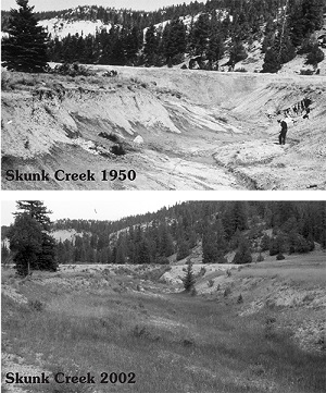
Google Earth on the Range Repeat Photographs
Take a tour of Utah rangelands with historical photos. This kit includes 16 pairs of laminated photographs. Each pair of photos shows one location in Utah's rangeland at two different points in time, illustrating how factors like grazing, erosion, and management affect the landscape over time. Order these photographs online at agclassroomstore.com.
Author
Utah Agriculture in the Classroom